
Canada1Water New Publication and Data Release Notice: Hydraulic Parameterized Integrated Soil, Bedrock and Peatland Dataset

Kessel, E. D., Frey, S. K., Lapen, D. R., Geng, X. & Russell, H. A. J. (2026). Canada1Water: Hydraulic parametrized integrated soil, bedrock and peatlands datasets. Data in Brief, 112636. https://doi.org/10.1016/j.dib.2026.112636
Click Here To Learn More.
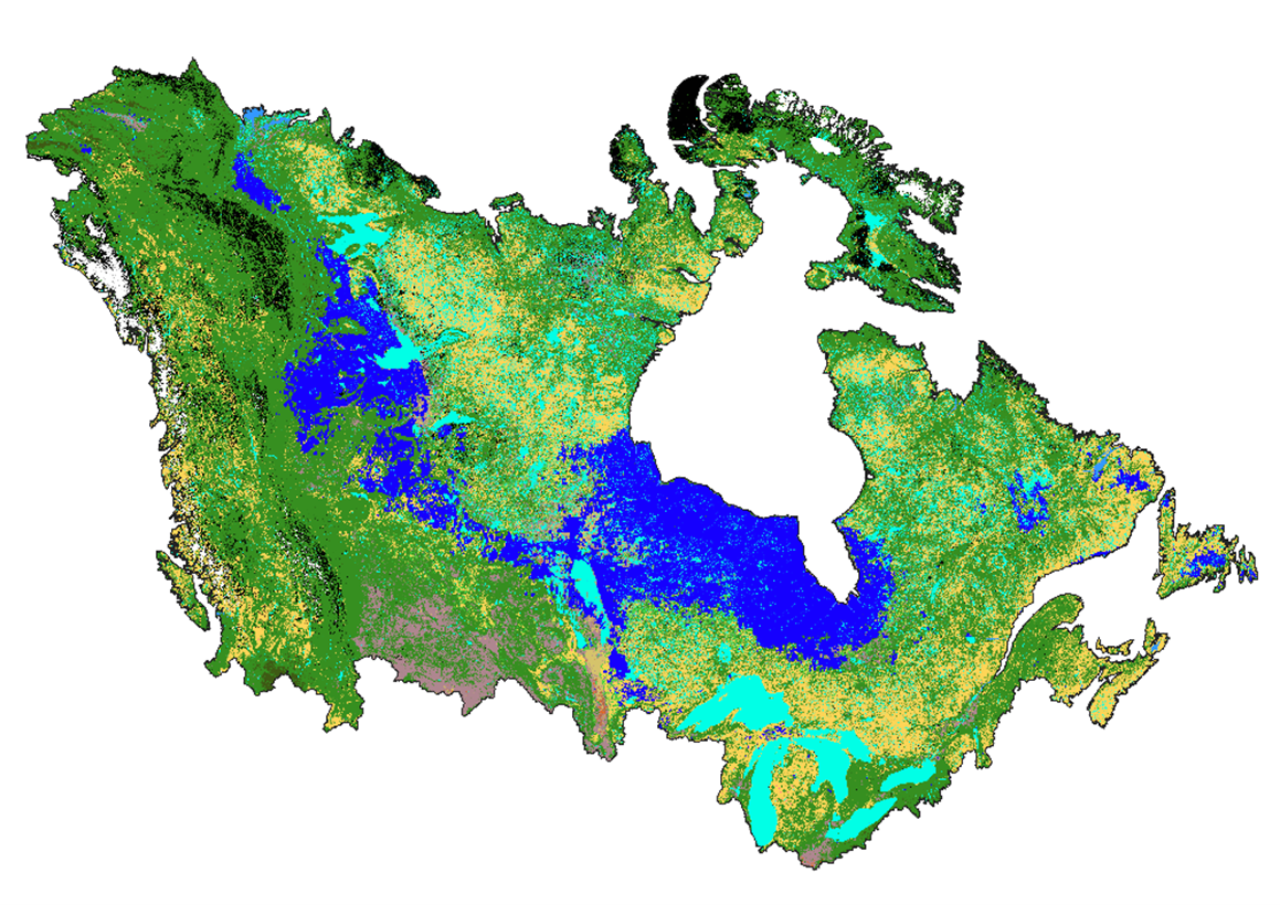
Here we see what the Soil Map 1 looks like which represents the top soil layer from 0 to 50 cm below the ground surface. The mineral soil textures are greens and yellows, where the peatlands are blue and bedrock outcropping is black. Each pixel has its own soil texture and respective hydraulic parameters!
The Canada1Water soils dataset has now been published in Data in Brief. The peer-reviewed article documents the methodology used to develop national-scale soil, bedrock, and peatland datasets designed to support integrated hydrological modelling across Canada and transboundary watersheds.
This work introduces a 250 m resolution, hydraulically-parameterized dataset integrating mineral soils, bedrock outcrops, and peatlands into a consistent framework for groundwater–surface water modelling and HydroGeoSphere (HGS) applications.
What: Development of the Canada1Water (C1W) national soils dataset representing near-surface materials across Canada, including mineral soils, exposed bedrock, and peatlands with hydraulically parameterized properties. The dataset provides seamless ~250 m spatial resolution coverage across continental Canada and transboundary watersheds with the United States, organized into two soil layers (0–0.5 m and 0.5–1.0 m below ground surface). Hydraulic properties such as residual and saturated water content, van Genuchten parameters, and saturated hydraulic conductivity were derived using Rosetta v3 pedotransfer functions applied to OpenLandMap soil property data.
Why: Accurate representation of soils, bedrock, and peatlands is essential for modelling infiltration, groundwater recharge, and surface–subsurface water interactions. The Canada1Water soils dataset provides a standardized national framework designed to support continental-scale hydrological modelling, climate impact analysis, and water resource management. By integrating soil texture, hydraulic parameters and peatland and bedrock classifications on a common grid, the dataset supports consistent numerical modelling using tools such as HydroGeoSphere and other land surface models.
Where: This data release is accompanied by a peer-reviewed methodology publication in Data in Brief. We are also introducing the Canada1Water Zenodo Community, which will serve as a permanent repository for published C1W datasets while continuing to support access through the Canada1Water data portal.
Who: The release is a product of Canada1Water team, a collaboration between the Geological Survey of Canada, Aquanty, and Agriculture and Agri-Food Canada.
Downloading the Data
Step 1) Read the peer-reviewed methodology
The dataset methodology is described in the Data in Brief publication.
Step 2) Access the C1W Data Portal
Canada1Water datasets are available through the C1W Data Portal.
Click Here to Access the Portal
Step 3) Navigate to the “Canada1Water” map tab
The ’Canada1Water’ tab can be accessed from the menu on the left side of the portal interface.
Step 4) Visualize the 1×1-Degree or 10×10-Degree Tiles data layer
Click the Layer Menu at the top right of the Canada1Water map to select available layers. The 1×1-Degree or 10×10-Degree Tiles data layers are available under the ‘Canada1Water’ category.
Step 5) Click on an individual tile to download available data
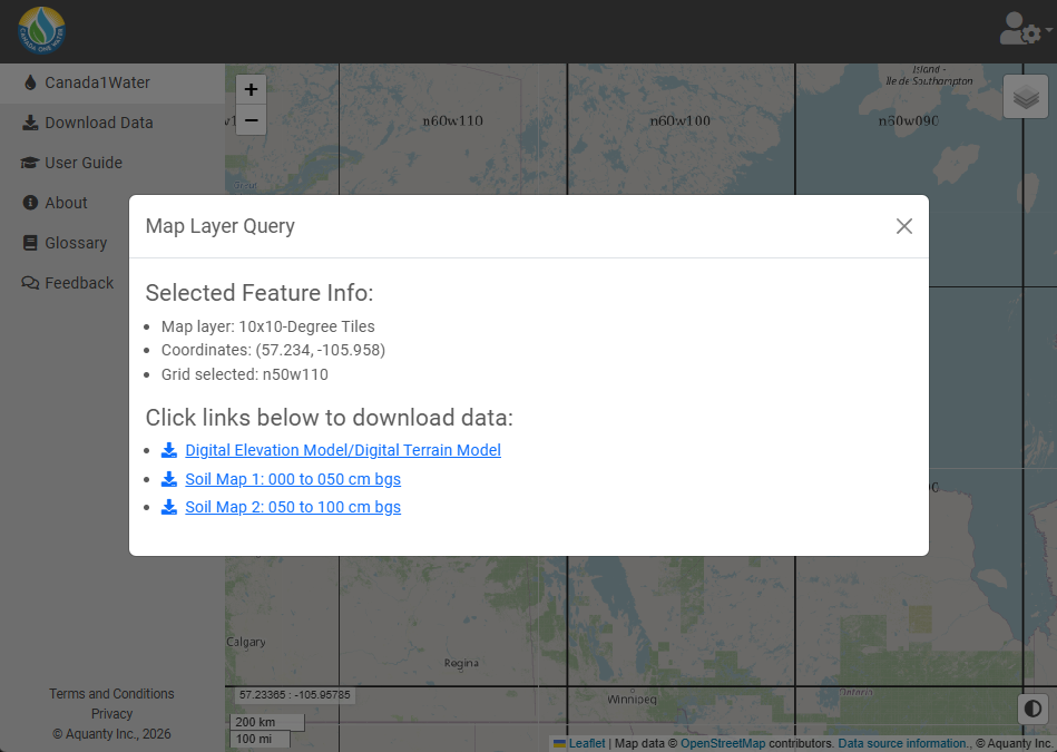
Clicking on an individual tile will open a menu which displays available datasets for download (see image to right)
Optional) Access the Dataset through Zenodo
Canada1Water datasets are also archived in the C1W Zenodo Community, providing long-term access and citation for published datasets.
Dataset Records:
Kessel, E. D., Frey, S. K., Lapen, D. R., Geng, X., & Russell, H. A. J. (2026). Canada1Water hydraulic parametrized integrated soil, bedrock and peatlands dataset: Soilmap 1: 000to050cm (1.0) [Data set]. Natural Resources Canada. https://doi.org/10.5281/zenodo.17793698
Kessel, E. D., Frey, S. K., Lapen, D. R., Geng, X., & Russell, H. A. J. (2026). Canada1Water hydraulic parametrized integrated soil, bedrock and peatlands dataset: Soilmap 2: 050to100cm (1.0) [Data set]. Natural Resources Canada. https://doi.org/10.5281/zenodo.17796326